

Did you know the FSC publishes fold out charts and guides? Find out more.
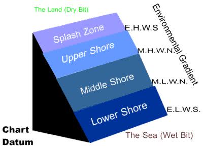
The precise heights of these zones will depend on where you are. All tidal heights are measured from a local datum point (Chart Datum). Effectively this is the lowest the tide ever gets and is called 0 metres (or whatever unit you are using) For Milford Haven (where Dale Fort is in West Wales) the heights on the diagram are as follows:
ExtremeLowWaterSprings = 0.0m.............MeanLowWaterNeaps = 2.5m................
MeanHighWaterSprings = 5.2m................Extreme HighWaterSprings = 7.8m
Mid-Tide point therefore, 3.9 metres above chart datum
The bits of shore covered by the water EHWS to ELWS we call the littoral zone. The bit below the lowest tides we call the sub-littoral zone. The dramatic environmental changes that occur from over the small physical space from the bottom to the top of the shore result in a massive variety of organisms all crammed into this small space. People sometimes say that (in terms of changes in environmental conditions) moving from the bottom to the top of the shore is like moving from the equator to the poles in terrestrial environments.
Looking for a next step?
The FSC offers a range of publications, courses for schools and colleges and courses for adults, families and professionals that relate to the seashore environment. Why not find
out more about the FSC?

FEEDBACK
Do you have any questions?
Copyright © 2008 Field Studies Council

Creative Commons Attribution-Noncommercial-No Derivative Works 3.0 Licence .
Site Statistics by Opentracker